Why does the sea seem to vanish after a strong earthquake?
Powerful earthquakes do not just cause tsunamis and landslides. They can also make the sea move back permanently and expose the seabed below.
This phenomenon is called coastal uplift, and it usually happens when the seabed rises above sea level after the up-and-down movement of an earthquake. This is according to the definition by the Philippine Institute of Volcanology and Seismology (Phivolcs).
When this happens, a large portion of the sea seems to vanish, exposing the coral reefs and marine life that used to live below the water. But in reality, the tide has just been pushed back as a result of the raised coast.
How does coastal uplift happen and what are its effects? Here’s what you need to know:
What causes coastal uplift?
Vertical deformations of the coast can happen in response to the up-and-down motion of the earth’s crust along a fault or trench.
Coastal uplift is one of two ways that a coast can change because of this process, specifically by raising the seabed above its previous tide levels. This phenomenon results in “widened coastal areas, seaward shift of high tide lines, and exposed coral reef systems, marine plants, and animals,” Phivolcs said.
Subsidence, on the other hand, does the opposite, making the sea move forward and the coast more narrow.
Both of these coastal changes can happen in two ways, according to Phivolcs. Coseismic uplift occurs abruptly because of an earthquake, while interseismic uplift happens gradually as the earth’s crust naturally moves and progressively deforms.
According to the United Nations Office for Disaster Risk Reduction (UNDRR), the difference between these two phenomena lies in how the earth’s crust moves. Coastal uplift is associated with the convergence of plates, while subsidence is usually related to plates moving apart.
The causes of these phenomena aren’t just limited to earthquakes, though. “Subsidence and uplift are driven by a variety of natural and anthropogenic processes,” the UNDRR added. These include:
- mining or tunnelling
- consolidation
- sinkholes
- groundwater fluctuations
- moisture changes on expansive soils, groundwater extraction
- tectonic processes
- volcanic unrest
- isostatic changes from sediment or ice loading or removal
- mantle flow
Particularly strong earthquakes can make these uplifts either permanent or persistent, sometimes lasting several decades, according to the UNDRR. The extent of an uplift can also depend on the type, magnitude, depth, and distance of the affected area from an earthquake.
Is it dangerous?
According to the UNDRR, these phenomena are “not generally destructive” save for coastal areas. They can have significant impacts on harbors, since coastal uplifts can lead to “dramatic decreases in their depth and utility.”
In the Philippines, coastal uplift has also been reported to cause damage to marine ecosystems, killing corals, seagrass beds, and resident organisms such as reef fishes, eels, clams, and shells.
For example, a magnitude 7.8 earthquake that hit Sarangani province in June 2026 caused an estimated 2.5-meter rise of the shoreline in Barangay Balangonan, Jose Abad Santos, Davao Occidental, according to Phivolcs. This resulted in a more than 200-meter difference in the high-tide levels before and after the earthquake.
Habitat damage was also reported in Pangyan Marine Sanctuary, Barangay Pangyan, Glan, Sarangani province, according to the Department of Environment and Natural Resources (DENR) in Soccsksargen. Similar coastal uplift levels as those in Davao Occidental were reported in this area.
“Nearby residents were concerned that the stench of decaying marine life could poison them,” DENR Soccsksargen added.
The UNDRR also warned of a “multi-hazard context” where different hazards of uplift and subsidence can interact and drive each other.
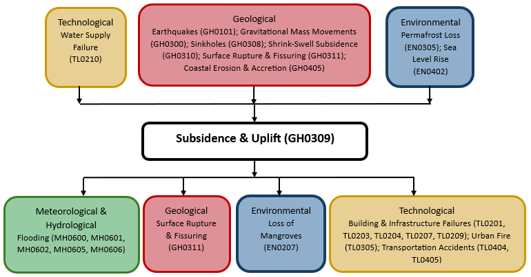 MULTI-HAZARD CONTEXT. This chart summarizes common interactions between subsidence and uplift and other hazards. Figure from the United Nations Office for Disaster Risk Reduction
Can coastal uplifts be prevented?
No technology that can prevent coastal uplifts and other earthquake hazards exists yet, but the UNDRR said planning around these hazards is possible.
“Coastal change can impact harbour water depth and damage infrastructure. In these zones, modelling to enable adaptive planning is the best form of mitigation,” they said. – Rappler.com


You May Also Like

How On-Chain Treasury is Solving the Biggest Cross-Border Risk in Emerging Market Corridors

SoarPay’s New Payment Processing Book Reaches Amazon Bestseller Status and #1 New Release in E-Commerce

Lagarde dismisses early‑exit talk, says she will stay ‘on deck’ at ECB to ensure price stability